

Collection: Osher Map Library Collection
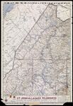
Name: The Phillips Map of Northern Maine's St. Johns-Allagash Wilderness featuring the Allagash Wilderness Waterway State Park and indicating the lake to be created if, or when, the Dickey Dam is built
Barcode:
Image Number:
Creator:
Publisher:
Date/Date Range Produced:
Date/Date Range Published:
Language:
Region Depicted:
Dimensions: 36 x 44
Notes: "Copyright 1967 & Published by Augustus D. Phillips & Son - Northeast Harbor Maine - U.S.A."
Physical Description: 1 map: color, illustrated
Accession Number: OML-1967-17
Donor:
Permanent URL: